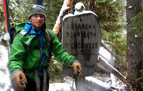
Jim Harris traversing the Northern Absaroka
The Absaroka Range is the remnants of a massive (9,000-square-mile)
volcanic plateau that extends for roughly 150 miles in a northwest-southeast
direction across the Montana-Wyoming border. Stream and glacial erosion have
sculpted spectacular features from the poorly consolidated volcanic debris.
Steep rocky slopes, jagged peaks, deep valleys, thick forests, and alpine
meadows are home to healthy populations of grizzly, wolf, elk, eagle,
wolverine, big horn sheep, elk, moose, mountain goat and bison.
Rocky Mountain Bighorn Sheep
The establishment of Absaroka-Beartooth Wilderness, North
Absaroka Wilderness, Teton Wilderness, Washakie Wilderness, and Yellowstone
National Park, has honored the region by protecting its natural and wild
character. Little has changed since 1871 when legendary surveyor Ferdinand
Hayden wrote: “On the east side of the Yellowstone the eye takes in at a glance
one of the most symmetrical and remarkable ranges of mountains I have ever seen
in the West.”
In early June 2012, with financial support from the Hans Saari Memorial Fund, Jim Harris and I took advantage of lingering spring snow and completed a high ski traverse along the northern half of the Absaroka Range. Starting at Pahaska Tepee near Cody, Wyoming, we hiked and skied over 100 miles (including over 30,000 feet of vertical gain) in seven days to Mill Creek near Livingston, Montana.
Crossing a raging Grinnell Creek
Approaching Hoodoo Peak
Late Season Ridge Cruising
Following the White Line
Cutting Turns on Daisy Pass
Adventure Photography
New snow at 7,000 feet!
Jim Harris leaving the Absaroka Beartooth Wilderness


Been stoked about reading this report since you hinted at it in that great post awhile back about ski setups for all seasons, Forrest. Good on you guys for putting skis to snow and boots to dirt for a very elegant route "up north".
ReplyDelete