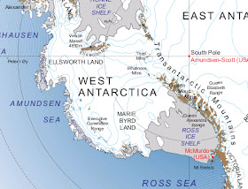
West Antarctica is remote, even by Antarctic standards. Most of West Antarctica has never been claimed by any sovereign nation. With an area of 620,000 square miles it is by far the largest single unclaimed territory on Earth.
West Antarctica
Located within the Western Hemisphere, West Antarctica is bounded to the north by the Pacific Ocean, to the south the Transantarctic Mountains, to the west the Ross Sea, and to the east the Antarctic Peninsula. The West Antarctic Ice Sheet (WAIS) covers much of the region. Observations indicate that the ice sheet is shrinking and therefore a priority for scientific inquiry.
Byrd's First Antarctic Expedition 1928
Byrd’s third Antarctic Expedition, known as the United States Antarctic Service Expedition, took place from 1939-1941. This expedition established two base camps 1,600 miles apart. West Base was located on the Ross Ice Shelf and East Base near the Antarctic Peninsula. Exploratory flights out of these two bases mapped most of West Antarctica’s coastal region. During the same expedition overland parties from West Base visited the northern Ford Ranges and southern slopes of the Fosdick Mountains.
POLENET 2010
Video by the National Science Foundation
East Base Personnel, 1939 United States Antarctic Service Expedition
In 1939, President Franklin D. Roosevelt instructed members of the United States Antarctic Service Expedition to make a land claim in Antarctica. While none of the resulting claims were formalized prior to 1959 when the Antarctic Treaty System was established, during the intervening period occasional U.S. publications have shown West Antarctica as a United States Territory. More recently the United States Defense Department in 1996 stated there’s a legitimate basis for a territorial claim.
“…the United States has a solid basis of claim in Antarctica, resulting from its activities there prior to 1959.” – William J. Burns, Deputy Secretary of State
Exploration
The British Discovery Expedition, on route to Ross Island, first sighted West Antarctica in 1902. The first to enter its icy recesses, however, were a sledging party from the 1910 Norwegian Antarctic Expedition. Exploration of West Antarctica has continued primarily from the west where the ice-free waters of the Ross Sea provide the most reliable access point.
Byrd's First Antarctic Expedition 1928
Later, in 1929, Richard E. Byrd's first Antarctic Expedition established Little America and conducted aerial over flights and named the region Marie Byrd Land, after the Admiral’s wife. During this same expedition, Lawrence Gould led a small geological party that briefly explored parts of the Rockefeller Mountains that define the southwestern edge of West Antarctica.
The first significant overland exploration of West Antarctica occurred during the Byrd’s second Antarctic expedition (1933–1935). Paul Siple led a sledge party eastward to the Fosdick Mountains.
Tractor in a Crevasse, 2nd Byrd Antarctic Expedition
Byrd’s third Antarctic Expedition, known as the United States Antarctic Service Expedition, took place from 1939-1941. This expedition established two base camps 1,600 miles apart. West Base was located on the Ross Ice Shelf and East Base near the Antarctic Peninsula. Exploratory flights out of these two bases mapped most of West Antarctica’s coastal region. During the same expedition overland parties from West Base visited the northern Ford Ranges and southern slopes of the Fosdick Mountains.
Tractor Traverse, Little America November 1957
Photo courtesy of Charles Bentley
The United States Navy organized several expeditions to Antarctica in the period 1946 to 1959 including Operation Deep Freeze when an operations team from Little America traversed overland to establish Byrd Station near the center of West Antarctica. These efforts were in advance of the International Geophysical Year (1957-1958) when multiple research oriented overland traverses were conducted.
Bentley Subglacial Trench
Starting in January 1957 glaciologist and geophysicist Charles R. Bentley led a tractor traverse from Little America to the new Byrd Station. During the traverse, Bentley and his colleagues conducted measurements of ice thickness and studied the Earth’s magnetic and gravity fields. During the following summer seasons Bentley led two overland traverses through previously unexplored regions of Marie Byrd Land. The discovery of a deep bedrock chasm between West and East Antarctica (known as the Bentley Subglacial Trench) was made at this time.
ITASE Tractor Traverse
Photo by the Antarctic Sun
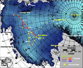
Subsequent to these early overland traverses multiple scientific expeditions have explored West Antarctica. Between 1999 and 2002 the International Trans Antarctic Scientific Expedition (ITASE) made a series of tractor traverses across the West Antarctica Ice Sheet. Under the leadership of Dr. Paul A. Mayewski, the United States component collected ice cores that significantly increased knowledge of atmospheric conditions during the last 200 to 1,000 years.
U.S. ITASE Route Map
Most recently, Colorado College geologist Dr. Christine Siddoway organized expeditions to the Ford Ranges and the Fosdick Mountains. These expeditions are part of a long-term research program exploring the geological evolution of Marie Byrd Land.
Fosdick Mountains, Antarctica
In 2006-2007, I assisted Dr. Christine Siddoway in the Gneiss Dome architecture: Investigation of Form and Process in the Fosdick Mountains. Additional expedition members included Dr. Fawna Korhonen, and Dr. Rory McFadden and Mike Roberts. We had planned a sledging traverse of the Fosdick Mountains using snowmobiles. Unfortunately our fieldwork was impacted by an unprecedented storm that destroyed much of our field equipment (our snowmobiles even blew away!) resulting in an emergency evacuation.
A Scott Tent after being battered by 120+ mile an hour winds
Fosdick Mountains, 2006
Byrd Station
Late in1956, as part of Operation Deep Freeze, a joint Army, Navy, Air Force, and Marines tractor traverse left Little America. Their mission was to establish Byrd Station on a predetermined point in the the middle of West Antarctica. The tractor train, led by Army Major Merle Dawson, traveled 646-miles across the unexplored interior of West Antarctica.
Byrd Station, 1957
Photo courtesy of Charles Bentley
Initially the station consisted of four prefabricated buildings. An underground station was constructed in 1960 and was occupied year-round until 1972. The station was then converted into a summer-only field camp that has been utilized periodically ever since.
POLENET 2010
From 2009 to 2012 Byrd Station served as the West Antartic base camp for POLENET. Dedicated to observing changes in polar regions, POLENET focuses on collecting GPS and seismic data from autonomous systems deployed at remote sites spanning much of the Antarctic and Greenland ice sheets.
WAIS Divide
Video by the National Science Foundation
In 2005 a large seasonal field camp was established near the divide between ice that flows east into the Amundsen Sea and ice that flows west into the Ross Sea. The camp supports an effort to create the largest and most detailed record of greenhouse gases possible for the last 100,000 years called the West Antarctic Ice Sheet Divide Ice Core. On December 31, 2011 the project reached its final depth goal of 3,405 meters, recovering the longest U.S. ice core to date from the Polar Regions.
Pine Island Glacier
In 2010, the United States Antarctic Program (USAP) established a seasonal field camp next to the Pine Island Glacier to support research near the coast of West Antarctica, including a project titled Ocean-Ice Interaction in the Amundsen Sea: the Keystone to Ice-Sheet Stability. The project is studying how a warming climate is impacting the West Antarctic Ice Sheet. The project involves spending time on the actual glacier to conduct seismic work and drill through the ice to deploy instruments under the ice.
The Pine Island Glacier (PIG) Camp, located nearly 1,400-miles from the USAP's main facility, McMurdo Station, supports local air operations that include both ASTAR Helicopters and Twin Otters. The population can reach 30 people. The fuel for this "glorified" gas station was hauled 400-miles by tractor from Byrd Station and WAIS Divide.


Hi, thanks for your informations, How do you explain the fact that Marie Byrd Land has not been claimed yet?
ReplyDeleteYuri Leveratto
www.yurileveratto.com
"No acts or activities taking place while the present Treaty is in force shall constitute a basis for asserting , supporting or denying a claim to territorial sovereignty in Antarctica or create any rights of sovereignty in Antarctica. No new claim, or enlargement of an existing claim to territorial sovereignty in Antarctica shall be asserted while the present Treaty is in force" - AntarcticaTreaty, 1959
DeleteIt has been claimed. Read more carefully. The U.S. has a claim to Marie Byrd land due to discovery occupation dating at least from 1929, well before the entry into force of the 1959 treaty (which did not extinguish existing claims). Read the article more carefully.
Delete