
Michael Fiebeg, Thorofare Creek
The Du'Mor' packrafting route starts in the Dunoir near Dubois and finishes on the Buffalo Fork River near Moran, Wyoming. The route links four wilderness rivers by crossing three high mountain passes (including the continental divide) through the most remote country in the contiguous 48 states.
On July 6 -11, 2013, Michael Fiebig, Jim Harris, Forrest McCarthy, Andrew McLean, and Moe Witschard completed the 97-mile route through Wyoming's Washakie and Teton Wildernesses.
South Fork of the Shoshone River

Andrew McLean, Shoshone Pass
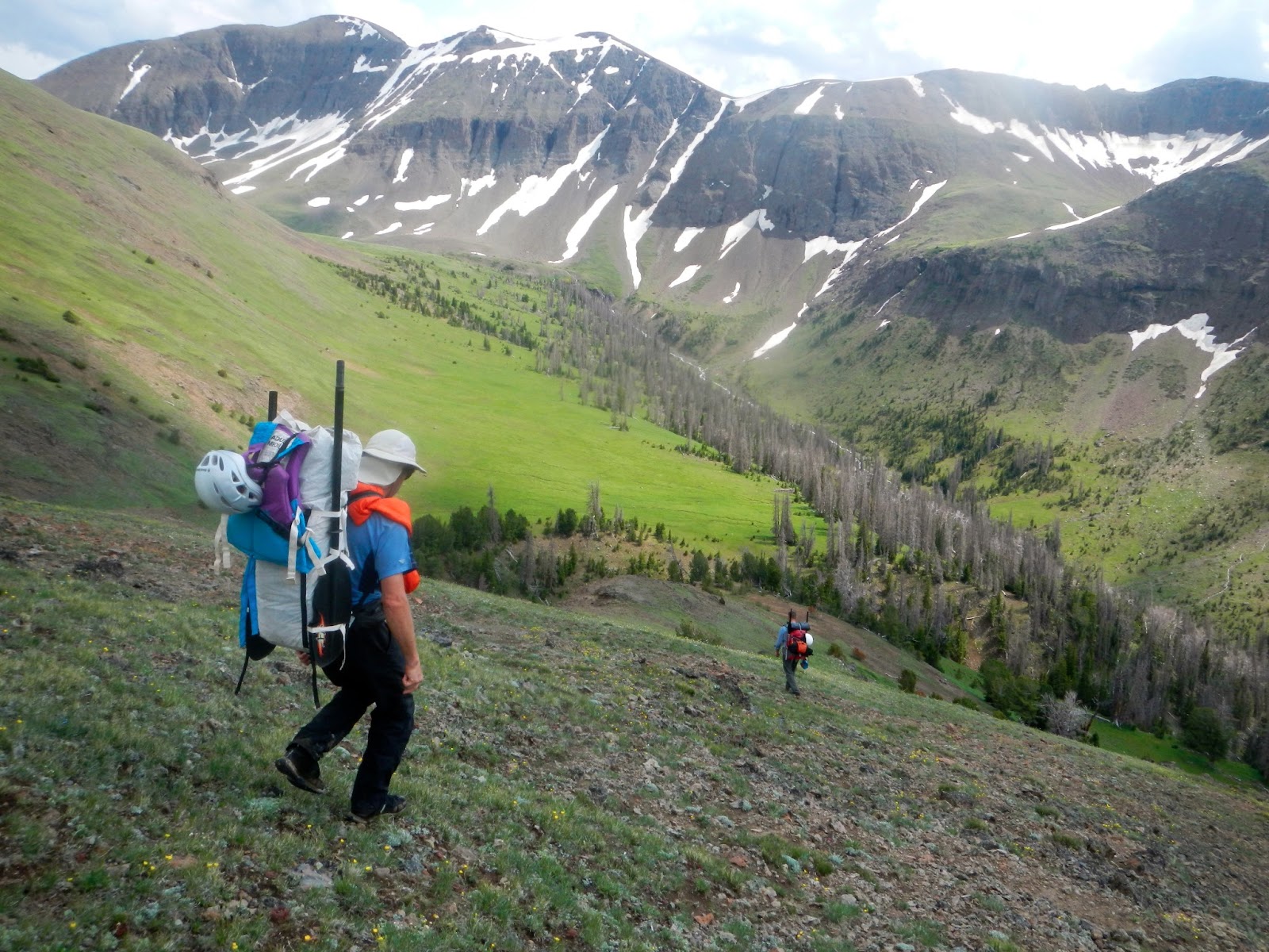
The Du'Mor' route starts near Dubois, Wyoming in the Dunoir Special Management Area. A13-mile scenic hike over Shoshone Pass took us to Bliss Creek Meadows.

Paddling Bliss Creek Meadows, Washakie Wilderness
Our second day was spent descending the South Fork of the Shoshone River. We put in at an elevation of 8,200 feet and enjoyed several miles of blissful paddling before our first portage.

Portaging the First Gorge
Directly below Bliss Creek Meadows the South Fork enters a tight woody canyon that starts with a sieve. To avoid this treacherous section we carried our boats for over a mile along the well-maintained horse trail that parallels the river.

Jim Harris gearing up
Marston Creek to Fall Creek is steep, sustained and fast. It is mostly Class III with the ocasional Class IV(V) drop or river wide log that ensures a high level of adventure.

Moe Witschard enters the 2nd Gorge
One of the best sections of the South Fork is the 2nd Gorge that begins near the confluence with Younts Creek. The entrance involves a long section of Class III followed by a surreal section of Class II. For nearly a hundred yards the river fills the narrow the gorge wall to wall.

2nd Gorge of the South Fork of the Shoshone River
This was the third time I have run the South Fork. On my last descent the 2nd Gorge was completely choked with wood and un-runnable. This year we found it completely clean other than the old log bridge that spans the river at the narrowest spot.
 Jim Harris, 2nd Gorge of the South Fork of the Shoshone River
After the entrance slot the 2nd Gorge opens up some, yet continues to provide enjoyable creeking.

In between each of the four gorges the valley widens, the whitewater eases, and mountain views expand.

Class V?
The third gorge contains sustained Class III whitewater punctuated by thrilling Class IV drops and several mandatory portages. If free of wood, the two drops we bypassed would provide an expert boater a thrilling challenge.

Portaging a log infested steep drop

Jim Harris, South Fork of the Shoshone River
The day we ran the South Fork the USGS Gage reported 2,000 cfs. I've run this stretch of river at both higher and lower flows but found this to be an ideal level. The water was not "pushy" yet sufficiently deep.

Crossing Fall Creek, Washakie Wilderness
On this trip we exited the river above the 4th and final gorge of the South Fork of the Shoshone River and on our 3rd day followed a rough mule trail up Fall Creek to the crest of the Absaroka Range.

Lunch Time in the Washakie Wilderness

Wolf Tracks

Timberline at the head of Fall Creek
Crossing from the the South Fork of the Shoshone to Thorofare Creek involves an arduos yet spectacular 5,000 foot climb over the crest of the Absaroka Range.
Crossing an 11,000 ft pass in the Absaroka Range

Fossilized Wood
Andrew McLean descends into Bruin Creek
Rugged unnamed peaks define the remote crest of the Absaroka Range that divide the Teton and Washake Wildernesses and Shoshone and Yellowstone rivers.

Following a mule trail down Bruin Creek
While not shown on any maps. a well-defined trail follows Bruin Creek down to its confluence with Thorofare Creek. The trail appears well-used but the treacherous footing would make for some exciting riding or horse-packing.
Thorofare Creek

Thorofare Camp, Teton Wilderness
Our third night is spent camped at the confluence of Bruin and Thorofare creeks over 20 miles up-stream of the most remote location (furthest from any road) in the 48 contiguous states.
Thorofare Creek
The Teton and Washakie Wildernesses combined with adjacent roadless areas including the southwest corner of Yellowstone National Park comprise a 2.1 million acre road free wilderness, one of the largest in the lower 48 states. Thorofare Creek drains the regions center and is arguably the most remote stretch of navigable water south of Canada.

Wapiti
The Thorofare ranks among this nation's best wildlife areas. Trumpeter swans, sandhill cranes, eagles, falcons, and song birds soar above. Otter, beaver and cutthroat trout inhabit its waters. Grizzly bears, gray wolves, wolverine, elk, moose and bison wander along its shores.

Thorofare Creek
Initially the creek is small and barely navigable. Frequent tributaries including Butte, Pass, and Open Creeks, however, soon create a broad Class II waterway that is mostly clear of wood.

Michael and Andrew, Thorofare Creek
The day we ran the 15 miles from Bruin Creek to Hawk's Rest the USGS River Gage at the outlet of Yellowstone Lake reported 3,000 cfs.
Hawk's Rest Mountain and the Yellowstone River
After flowing past Hawk's Rest Mountain Thorofare Creek enters Yellowstone National Park where packrafting is unjustly banned. If the Park Service ever changed their absurd policy by allowing one of the most elegant and ephemeral means of wilderness travel, the Yellowstone and Snake Rivers would provide alternative finishes to the Du'Mor' packrafting route.
From Hawk's Rest a 20-mile hike brought us over the Continental Divide at Two Ocean Pass and into the headwaters of the Buffalo Fork River.
video by Roman Dial
When I first completed the Du'Mor' Route in 2008 with Roman Dial and Derek Collins, we finished by paddling Pacific Creek. However, Pacific Creek drains lower terrain than the Shoshone River and by the time the South Fork is no longer flooding from snowmelt, Pacific Creek has often already dried up.
Buffalo Fork River
Soda Fork Meadows
Alternatively, we chose to finish on the Buffalo Fork River.

Moe Witschard, North Buffalo Fork River
The North Buffalo Fork is one of the best packrafting trips in Jackson Hole and a fantastic finish to the Du'Mor' Route. The upper meadows would provide serene paddling through an alpine paradise but were too low for enjoyable traveling when we arrived. At the confluence with the Soda Fork, however, there was sufficient water for a highly enjoyable 5-mile float to the confluence with the South Buffalo Fork and our final camp.
HMG UltaMid, Buffalo Fork River
For a dramatic conclusion, we spent our last morning on a side trip to run the Class IV gorge on the South Buffalo Fork just upstream of the confluence with the North Fork.

Andrew McLean scouts one the South Buffalo Forks many rapids
For several miles above the confluence the South Buffalo Fork contains a series of notable Class III and IV rapids. Further up, above where we put in, is a serious Class V gorge that has been run by kayakers.

Michael Fiebeg negotiates one of the South Fork's bigger drops

Great Fun!

South Buffalo Fork River
Running both forks of the Buffalo made the ideal finish to a fantastic packrafting adventure through Wyoming's wildest corner. The USGS Buffalo Fork Gage reported 700 cfs.

Buffalo Fork River
Below the confluence of the North and South forks is the final gorge that contains several Class III rapids and sustained Class II whitewater fun for 5 fun miles to the Turpin Meadows Trailhead and our take out.
At the right flows the lower Class IV Gorge is an exciting run that can be combined with a run of the North Buffalo Fork during a long day trip.


That looks like an amazing trip. Incredible amount of ground you covered with some amazing views and water. Thanks for sharing!
ReplyDeleteThis comment has been removed by the author.
ReplyDeleteForrest you have an amazing vision for these trips. Thanks so much for creating this circuit.
ReplyDeleteOne thing to consider is that the "trail" in Bruin creek is quite challenging. Prepare for a pretty healthy day of off trail hiking to get down to the Thorofare. Lots of brush and downed trees and many pretty hard to cross flash flood ravines.
Kudos Forrest for another visionary trip.
There is an old outfitter mule trail that you can pick up near the head of Bruin Creek on the far or west side that makes for easy walking. Lower down it crosses Bruin Creek and joins a good horse trail where the North Fork of Bruin Creek comes in. But if you miss that trail the bushwhacking would be tough.
DeleteMe a 3 guys are thinking about doing this trip in July 2020. Is there any new info we should be aware of?
ReplyDeleteHi Forrest. You don’t happen to have the route for this trip in a .gpx or .kml file, do you? My buddy and I are going to try to recreate it next week as best we can (presumably with more walking and less floating, given the late season).
ReplyDelete