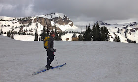
During the summer, following the Teton Crest Trail from Rendezvous Mountain to Jenny Lake is one of Jackson Hole's most popular hikes. And for good reason: easy access to an iconic alpine landscape makes for a fantastic Wilderness adventure. In late spring, traveling the route on skis is equally rewarding. Maybe even more so.
I had the pleasure of completing this classic Teton ski traverse with the Collins brothers. Having grown up in Alaska, and later moving to Jackson Hole, Dirk and Derek are true adventure artists. A cofounder of Teton Gravity Research, Dirk is currently the CEO of OneEyedBird Marketing & Entertainment. His more reserved younger brother Derek is an equally talented artist. They are both fantastic skiers.
Our traverse starts with a ride on the Jackson Hole Aerial Tram to the 10,450 foot summit of Rendezvous Mountain. From there we follow the standard route to Cody Peak before heading west of Peak 10,125 into the head of Granite Canyon and Grand Teton National Park.
Our route then takes us around the head of all three forks of Granite Canyon.
Middle Fork of Granite Canyon
With the advances in Alpine Touring (AT) equipment and equally impressive ski mountaineering accomplishments, it's often difficult to convey the joy of long adventurous ski traverses that link moderate terrain using Classic Nordic Skis.
Forrest and Dirk, Grand Teton National Park
photo by Derek Collins
Perhaps it is easiest to explain by comparing adventure Nordic skiing to the preference of some hunters to pursue game with a primitive bow or skilled fishermen that engage in traditional Japanese fly fishing known as Tenkara. Similarly, there exists elegance and beauty in the simplicity and tradition of Nordic skiing that relies heavily on skill and knowledge and less on expensive equipment.
Fox Pass, Teton Crest
After all, skiing is an art, not a science.
View of "Les Trois Tetons"
The aesthetics of a long ski line are also important. Not unlike a long vertical ski descent off a high summit, I find skiing long horizontal lines that traverse a mountain range (or large section of it) equally rewarding.
The Teton Crest is one such line.
One of the youngest mountain ranges in North America, the Tetons ironically contain some of the continent's oldest rock. The 2.5 billion year old metamorphic rock (primarily gneiss) that makes up the ranges highest peaks was forced upward by a tilted fault-block 6 to 9 million years ago during the Eocene. Known as the Teton Fault, approximately 30,000 feet (and counting) of displacement has occurred on the Teton's east (Jackson Hole) side.
Derek Collins, Alaska Basin/Avalanche Canyon Divide
On the range’s western slope are the weathered remains of 5,000 feet of Paleozoic sedimentary strata including massive deposits of limestones and dolomites. The high eastern edge of this sedimentary strata defines the Teton Crest and watershed divide. Characterized by long horizontal ledges, shelves, and ridges, the geography of the Teton Crest is ideal for long classic ski tours.
Dirk Collins of the Jackson Hole Air Force
Snowdrift Lake, Avalanche Canyon
photo by Derek Collins
After contouring around one glacier carved cirque known as Alaska Basin we return to the east side of the range and ski above Snowdrift Lake at the head of the South Fork of Avalanche Canyon. While the Teton Crest Trail crosses to the west at Hurricane Pass, the original "Skyline Trail" followed this same shortcut into Cascade Canyon. Covered in snow, long scree fields are easily negotiated.
Avalanche/Cascade Divide
From the Avalanche/Cascade divide we remove our kicker skins and prepare for a rapid 4-mile and 2,700-foot descent down the South Fork of Cascade Canyon.
South Fork Cascade Canyon
An unusual feature of the Teton Range is the highest peaks are not found along the watershed divide. Ancient fault-lines, aided by multiple glacier epochs, left long deep canyons that reach west of "Les Trois Tetons" (the three breasts) and to the north, Mount Moran. Cascade is one such canyon and we follow it north then east back into Jackson Hole.
South Fork Cascade Canyon
Several weeks of unseasonably warm weather drives rapid melting of the snowpack. While above 9,000 feet snow cover remains good as we descend, the spring thaw becomes increasingly evident.
From the confluence of the South and North forks of Cascade Canyon it's possible to continue north towards Lake Solitude and Paintbrush Canyon. This is the route many follow when hiking the Teton Crest or Skyline Trail. The complete Teton Crest Route, however, continues for an additional 25-miles to Survey Peak, the northern most peak in the range.
During the summer hiking season, connecting the southern Teton Crest or Skyline Trail with the northern Teton Crest Trail requires a three-mile trail-less scramble over Littles Peak. Starting at Teton Pass and traveling the entire 70-miles of the Teton Crest Route is a noteworthy multi-day backpacking trip or spring ski traverse.
We do neither. Just out for the day, we continue down Cascade Canyon and hitch a ride across Jenny Lake from the wonderful folks at Jenny Lake Boating.
On June 1st, Dirk Collins, Derek Collins, and I traveled the section of the Teton Crest from Granite Canyon to Cascade Canyon. Starting on the top of Rendezvous Mountain and finishing at Jenny Lake we skied 26.23 miles, climbed 4,049 feet, and descended 7,716 feet in eight hours.
“Some people satisfy the need for self-expression through
art or music. Although not recognized as artists, we, as adventurers, can
fulfill that same need through interactions with the landscape.” – Luc Mehl


Forrest - your trip reports are always thoughtful, detail-laden, and delightful to read. Thanks for taking the time to share your adventures, knowledge and to use a much-misused word which fits your tales: inspirational. Best, Thom
ReplyDelete